USFS


This was the first research study I went on when I joined the PNW Research Station (it was
a Mountain Pine Beetle study in La Grande, Oregon). You can see the dead trees in the background that were killed
by Mountain Pine Beetle.
I was told to drive a govt car full of equipment by myself from Portland out to a sawmill up in the Blue Mtns
outside LaGrande. I was so nervous,
worried I'd get lost, driving mostly on empty highways in eastern OR, afraid I forgot something, etc. etc.
And then I came around a corner and the highway was covered for a half mile by thousands of sheep. There were a
couple guys riding horses, and one in a pickup towing a small camping trailer. I went over to talk to the guy in the pickup,
but he only spoke a few words of english. I finally figured out all of them were Basques in the US for a year to tend sheep.
No one was in a hurry to push the sheep along, so as the sheep
meandered slowly by I got more and more relaxed, and finally when the flock withered to a few stragglers
I went on to the sawmill. Really couldn't have asked for a better intro to forestry research...
Tom Fahey is on the right in the second picture, a truly unique individual who always taught me new ways of
looking at a problem. He died
in a car wreck the night before his retirement party. The guy on the left was my boss for years, Dick Woodfin.
Woodfin taught me that you could find interesting things anywhere if you looked hard enough. He was always
up for stopping at some dinky museum we might pass out in the boondocks, and was the
first guy at the sawmill in the morning when we were doing a study. He was far and away the best boss I ever had.
I went to a party at his
house outside Portland a year or so before Covid, and he was about to leave for Idaho to lead a string of
mules into a wilderness area to take supplies to a remote lookout tower (I think he was 83 at the time).
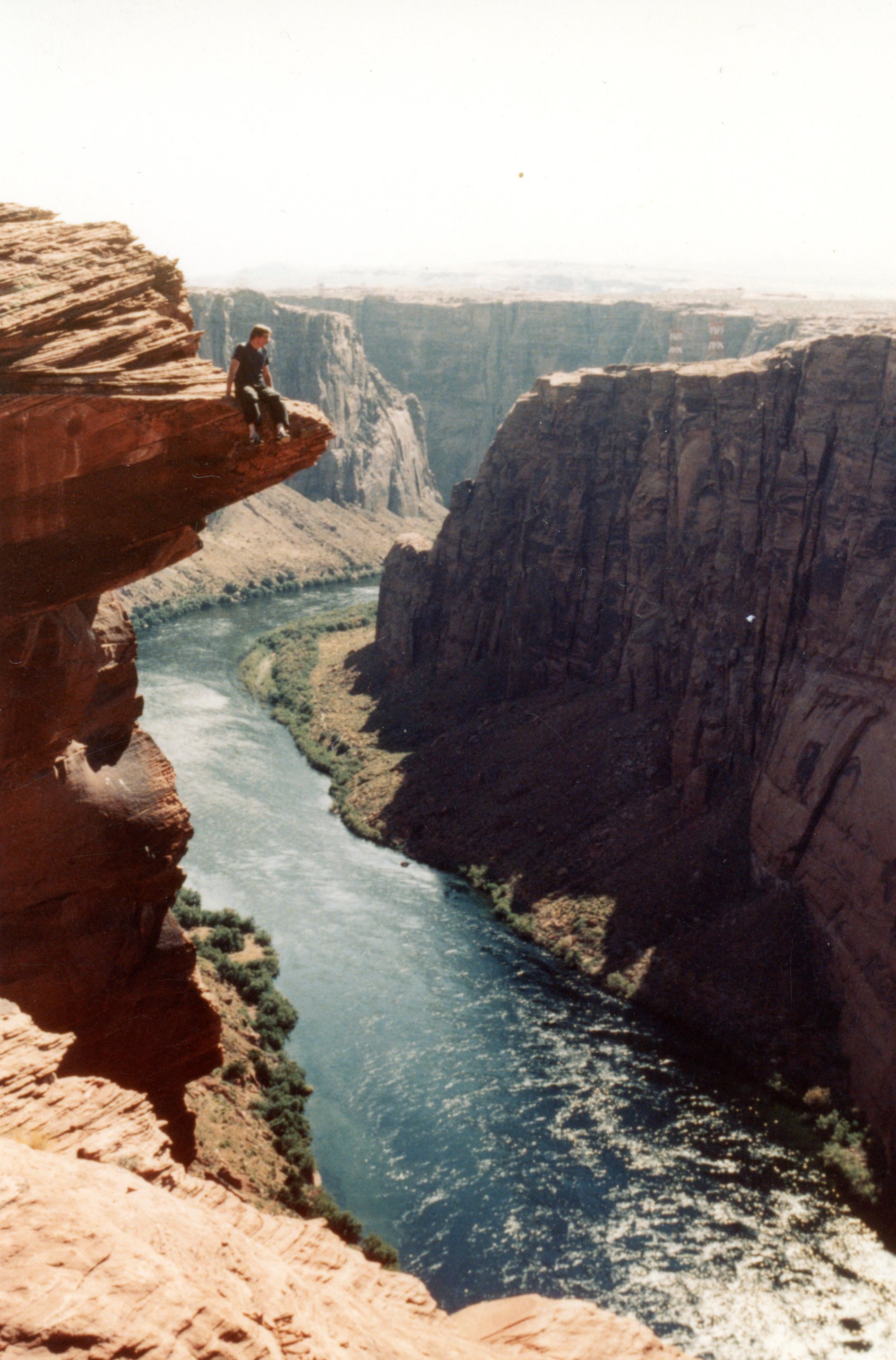
Dean Parry and I were doing the field work on a Ponderosa Pine study on both the north and south
rims of the Grand Canyon. We had to cross the Colorado River several times (at Glen Canyon Dam), and on
one of those crossings we discovered that over the years people had stomped down the fence that keeps idiots
from posing for pictures on a jut of rock above the river. So, um...

There was once an organization in the Forest Service named the Forest Service Artificial Intelligence group.
They met every year, and even published a professional journal (FSAI). I attended the national
conference in Seattle, and the following year I attended the national conference with Janet Sachet, this
time in Seeley Lake, Montana. It was held in a ghost town - actually a collection of abandoned
buildings that this guy moved onto his property to form a ghost town. It was very rustic. The intent of the
research group was to develop neural netsworks and knowledge-based systems that would be useful in forestry
research. I finally realized that AI is based on statistics - lots of statistics. And statistics are the
bane of my existence. So this trip to Seeley Lake was my last FS AI conference.

This would be on a study in northern New Mexico and Arizona (the mill was in Springerville, AZ).
All along the road were patches of century plants in bloom. Supposedly they only bloom every few decades,
amd all of them bloom the same year. Most of the employees at the mill were Zuni, and were able to talk
to each other across the mill using sign language. They were fond of signing something, then pointing to
one of us, and then several of the Zunis would start laughing.

We had a national meeting of the FS Remote Sensing Band at Gray Towers in Pennsylvania,
where Gifford Pinchot grew up (he is the guy who started the FS). Pinchot donated the forest
surrounding Gray Towers to Yale Univ, and it became the first research forest in the world (and is still the
Yale Univ research forest to this day). The 'castle'
is now owned by the National Park Service. In the 'sitting room/study' on the main floor you can still see the desk and
tables where Pinchot and Teddy Roosevelt drew boundaries of what became the National Forest System.
Apparently they had all these hand-drawn, very simple maps of the US from the military, trappers, and pioneers, and
Pinchot and Roosevelt just drew broad lines around huge areas of the country that they thought should be set aside as
'Forest Reserves' (some of the hand drawn maps are still on the tables there).
The small cottage on the property where we held our meeting did not have a phone,
so we had to go to the General Sherman bedroom in the 'castle', There was a guy at the meeting who grew
up in the
south, and he refused to go into the Sherman bedroom because Sherman burned down his ancestors' farms
during the 'war of northern aggression' and he was "damned if I'll sit in that bastard's bedroom".
So he sat in the hallway. Gray Towers features an outside dining room,
with the chairs pulled up around a stone pool of water the size and height of a very large dining table.
There were these wood boat-platters, and the butlers would put the dishes of food on the boat-platters,
and you would 'pass' the food around the table by launching these boat-platters across the pond. It was
featured in Life magazine. Must be nice to be rich, huh?

I gave a talk at a conference in Albuquerque, and they had a field trip to the Atom Bomb Museum. I'm not kidding,
there really is an atom bomb museum (its on an Air Force base in Albuquerque). I am leaning against one of the
largest atom bombs they ever made (hydrogen bombs were bigger). The only plane that could drop this bad boy
was that specially equiped B-52 in the backgound. BTW - some of the attendees at the conference were from
overseas, and the guards wouldn't let these foreign PhD forestry researchers on the air base to go to the atom bomb museum.

This was at a Remote Sensing Band meeting in Houston. We had the opportunity to tour
the Johnson Space Flight Center, and even got to go in the control room where all the moon landings
were run. Here is a pic of me and Rachel Riemann standing behind a Saturn-5 that was laying on
its side in the missile park deal that they had.

I spent many, many weeks working at the FS Remote Sensing Lab (RSL) in Salt Lake City, since they
had the skill and computers to handle very large data sets of satelite imagery. Salt Lake City
is only about 2 hours from Bonneville Salt Flats, so if a trip to the RSL coincided with Speed Week at
Bonneville, well, really I had no choice but to go there...


We did a big Western Red Cedar study in Orofino, Idaho (my birthplace - home of the
Maniacs). The cedar study calculated how much lumber, shakes, shingles, pickets, fence posts and fence rails
you could get from cedar logs. The point of the whole thing was to calculate how much the govt should
charge when they sell cedar. So this is the crew. The guy in the middle in the black had and pork-chop
sideburns is a mill worker assigned to our study. He would only tell us we had to call him Black Bart,
and his favorite pastime was throwing lit firecrackers at us when we weren't looking. The other mill
employee we had was Gene Sloppy, yes, thats his real name (he's on the right with his
hand on his head). I am second from the
left, holding a cedar hand split rail I had just split. The guy just to my left with the white hat
took a year off from forestry during college, and bought a trailer that had one of those carnival deals where you
swing a big heavy hammer and the deal goes up the tower, and if you ring the bell at the top you get a teddy bear.
He travelled with a carnival across Canada for a year, and man he had some stories.
A muddy mill yard in
Grangeville, Idaho. We ran the saw logs through the mill in Grangeville. The last picture is the infeed side
to the mill in Grangeville.

This was my crew on a Sugar Pine study in northern Caifornia. We spent several weeks
measuring heights and diameters and health of second growth sugar pine in the brushiest, hottest forests
I've ever been in. In these days of inclusivness and diversity, please look at this crew from back in
the late 1970's (I'm the white guy - the only white guy). My crew had one white female, one Japanese female,
one Native American female, a Philipino male, and a Mexican male. I was soooo ahead of my time...
Of course this is what you would expect when you get a crew from the forestry school at UC Berkeley.


This is a study of wind-thrown timber in SE Alaska. This is Rod Kelly and me in SE Alaska.
Rod was from the south, and when he came to
Portland his idea of forestry was small pulp logs from a flat bottomland forest. He hated the bugs in SE
Alaska. We stayed in a logging camp on one of the islands in SE Alaska, the camp was just a row of trailer
houses on either side of a gravel road leading up from the float plane dock. This was on one of the
'bear islands' in SE Alaska where Grizzley Bears are common, so we had to carry Forest Service issued rifles whenever we
were in the woods.


For about 4 or 5 years I was Smokey the Bear in the St Patrick's Day parade in
NE Portland. I also wore the Bear suit at Irving Park for the announcement of the 'Urban Tree House'
program, which was supposed to get inner-city kids in the woods. The Mayor was there, and the Regional Forester.
The Bear suit uses off-the-shelf Levis, but the upper part is a mesh fabric to make it cooler. There is also
a little fan in the head, but it never worked. The feet are huge, and it is easy to stub your toe. The only rules
for wearing the suit are 1) Smokey does not talk or growl, 2) never take off the head in public, 3) its okay to
put your hand on a child's shoulder,
but you can't put your hands on both shoulders at the same time, and 4) when you give a child a hug your hands must be between
their shoulder blades (we don't want an appearance of Smokey the Perv). Also, no patting children on the head.
This is not a propriety thing, it is to prevent the suit from getting infested with head lice.


Snow Peak Lookout in Idaho. My home for three months one summer.
Snow Peak is a mountain goat preserve, and every night about 20 goats would wander up and sleep
around the base of the 'tower'. Snow Peak is not accessible by road, and is a four mile hike to the nearest
road. When they took me and all my stuff in to Snow Peak it was by helicopter, and the only time I came down during the
summer was the night before Nixon resigned. They pulled in all the lookouts so we could watch the
resignation on TV. After all, he was our boss. The outhouse did not have a door,
and afforded a great view of the valleys below.


A couple of months after mount St Helens erupted, we started flying in by helicopter to measure
the extent of damage to the forest. The blown down trees were dead and brittle, with all the bark blown off on
the side facing St Helens. The ground was deep in pumice, and getting around was very difficult. The brittle
limbs on the trees were like sharp pokers. There were about 20 to 30 helicopters that flew in every day, with
reserchers from all over the world. We were assigned a helicopter pilot who refused to
fly over cemetaries. Go figure. BTW - the section of the tree stuck in the ground in the last pic is indeed
pointing downward - it flew like a spear, and jabbed into the ground during the eruption.